Louisiana's inclusion in Hurricane Eta's "cone of uncertainty" marks the eighth (Eta-ghth?) time we've been there this year. It's been quite a ride, folks.
Showing posts with label Hurricane Season. Show all posts
Showing posts with label Hurricane Season. Show all posts
Tuesday, November 10, 2020
Eta is enough

Friday, October 30, 2020
The wind wooshed around a lot
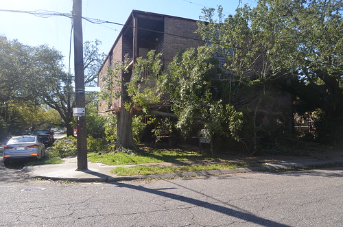
Yesterday I got out on the bike for a little while to see how bad it was around us. It wasn't all that bad, really. A lot of tree debris everywhere. Most not quite as extreme as the photo above but I didn't go very far. The roads were okay by the time I was out. But the night of the storm, one person was electrocuted by downed power lines which is horrifying. A lot of people still don't have power. 325,000 Entergy customers are still down as of this morning. But, generally speaking, for a high category 2 hurricane passing directly over the city, things could have been a lot worse.
It's not over yet, though. Sewerage and Water Board certainly had themselves a night on Wednesday.
Yet another New Orleans Sewerage & Water Board turbine failed Wednesday during Hurricane Zeta, although a spokesperson for the public utility said loss of that power source did not impair drainage.
Turbine 3 was brought online at the height of the storm but went down after “it reached its capacity,” S&WB spokesperson Courtney Barnes said. The turbine has typically been reserved for emergency use in recent years but was pressed into normal service for Zeta because Turbine 4, the largest of the S&WB’s operational turbines, broke Sunday.
Turbine 3 appears to have been activated as a back up for pumps that would have taken Entergy power under normal circumstances. But they made the switch when either that power or some other equipment failed. Anyway, it sounds like they were able to juggle and jerry rig their way through it. Happily, the storm moved quickly enough that the rainfall didn't put the pumping capacity to a serious test.
Yesterday, the city and SWB were asking people to use less water until they could be assured of full sewerage pumping capacity. But the details of that and several other issues were still incredibly vague as of this morning. McBride enumerates a few in this FB post. In the meantime, while it is still highly doubtful that there will be any Mardi Gras parades in 2021, I think several krewes have asked Turbine 6 to ride as a Grand Marshall
We are hearing some concerns about water being safe to drink due to power loss across the city. Power at our Carrollton Water Plant, where water is purified, maintained power throughout impacts from Zeta thanks to Turbine 6.
— SWB New Orleans (@SWBNewOrleans) October 29, 2020
This afternoon the Entergy map is still looking pretty Christamassy. Eyballing it, I think that looks like we might be close to 50% restored in Orleans Parish.
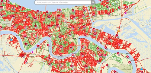
The Lens reports that the clerk of court needs 48 hours advance notice if we have to move any polling locations for Tuesday. 54 of them were without power as of today. Also in that article we read that the city is starting to get estimates as to the general cost of repairs. (It also happens to be city budget season and the outlook is not good.) As is the usual case with a major disaster, we would expect the federal government to reimburse these expenses. How much they pay out, though, might depend on certain data.
FEMA hasn’t approved a major disaster declaration for Hurricane Zeta yet, according to The Times Picayune/New Orleans Advocate, and is awaiting more complete damage assessments.
Cantrell said that the National Hurricane Center would also be reviewing data as to whether the storm was indeed at Category 2 or if it had slipped over the Category 3 threshold. That would have reimbursement implications, she said. Green said the city was also looking into federal assistance for individual residents over lost food.
It has been widely reported that Zeta's maximum winds may have been just 1 mph below the threshold for what we would consider a Category 3. If we had known at the time that this would make a difference, maybe we could have all gone out and waved some fans.
Wednesday, October 28, 2020
What did Zion say to Zeta?
Let's dance.

Man, I don't know about y'all but I haven't felt this giddy since February. Finally, something different is happening. It's happening fast too. This thing is hauling ass across the Gulf. Yesterday we were told to expect it to come in after 7 PM so people have planned their day according to that. City offices are open until noon. Schools haven't cancelled their virtual classes. This morning while I was out I saw the regular joggers jogging, the commuting, the panhandlers handling pans. People are determined to business up until the last possible businessing minute.
That's probably not the appropriate way to behave. And the current scenario where we see a hurricane accelerate and strengthen unexpectedly is a perfect example of why. The recent years of near misses followed by talk radio wise-assses complaining about "lazy" people taking the days off shouldn't have bullied us into this. But that's what happens when leadership is too sensitive to that kind of nonsense. I mean, you want them to be responsive to vox populi, but you also want to err on the side of safety whenever possible.
Hopefully it all works out. I always end up having to calm down the people around me in situations like this and one thing I try to do is remind them how little agency they have in any of it. Most events in this world transpire in total independence of our individual choices. The Saints win the game or they don't. The roof blows off of your house or it doesn't. It's just stuff that happens. Sometimes it affects you and sometimes it doesn't. But none of it is about you at all. Once you get that, you worry less.
Anyway, I had been planning to hit the grocery store one more time before the power goes out. I wonder if they are open.
Monday, October 26, 2020
We all just laugh
Look, we all knew there would have to be a Hurricane Zeta because there was just no way that the year 2020 A.D. was going out with the second most named storms in history. Got to tie that record at least. We also all knew that it had to make at least one serious run at Southeast Louisiana before this was over.
But we'll wait and see if it can follow through. So far, its aim has not been particularly impressive.
Wednesday, October 7, 2020
Colossus crawls west
Today's look has Delta coming in much stronger than we thought. And it's headed right for SW Louisiana where they're still literally picking up debris from Laura.


So that's not great. Can still change and probably will, though. But a shift back east is also not a great outcome.
Tuesday, October 6, 2020
The Friday Fizzle
It would be pretty typical for an October storm to lose strength as it crosses the northern Gulf. It's not guaranteed but it's something we've seen quite a few times. Anyway that's what this graphic seems to indicate even though the current status of the storm is freaking people out.

The problem is, if it happens, it's all going to happen on Friday. But if you have to decide what you are going to do before then, well, it might require a small leap of faith.
Monday, October 5, 2020
Breaking Records
They're going for it. All the mud.
The state is undertaking two “record-breaking” restoration projects aimed at reviving 7 square miles of coastal habitat and bolstering natural storm defenses east of New Orleans and near Venice in lower Plaquemines Parish.
Long planned but now funded with $215 million from money BP set aside after the Deepwater Horizon oil disaster, the projects amount to the largest marsh restoration and the largest coastal ridge-building effort the state Coastal Protection and Restoration Authority has ever attempted.
“The only way to describe them is 'massive,'” CPRA Executive Director Bren Haase said. “They’re both record-breaking projects."
The Deepwater Horizon disaster happened 10 years ago. These aren't the first projects that settlement has funded but they do give some idea of how long it takes to put that money to use. Which is a maddening thing to think about when we consider just how late in the game all of this is. This, for example, is from May of this year.
A new study says Louisiana’s coast cannot be saved.
Researchers looked at how the marshes have survived over thousands of years and concluded that they are past a major tipping point and sea level rise will eventually wash the entire coast away.
The study, published today in Science Advances, found that marshes can survive a certain amount of relative sea level rise — about a tenth of an inch per year. Sea levels are currently rising 1 to 2 inches a year in Louisiana due to climate change and subsidence.
“Previous investigations have suggested that marshes can keep up with rates of sea-level rise as high as half an inch per year, but those studies were based on observations over very short time windows, typically a few decades or less,” said Torbjörn Törnqvist, Lead researcher and Tulane University earth and environmental science professor.
He said officials have perhaps been too optimistic: “Unfortunately we have already reached the tipping point for marsh drowning in Louisiana. There is no way back anymore.”
Yeah... but you gotta do something. And since we do have some money to throw around right now, we might as well throw at something at least a little bit useful. And these "record breaking" projects do sound a little bit useful. One project aims to save and reinvigorate 3,000 acres of marsh around Lake Borgne.
Restoring marshlands in Lake Borgne, actually a large saltwater bay, is part of a wider effort to rebuild wetlands in the Pontchartrain Basin for both ecological and storm protection functions. Like much of the coast, the basin has been rapidly losing land from erosion, storm surges, rising seas and subsidence, the natural compacting and sinking of the soil.
A U.S. Army Corps of Engineers assessment found that boosting the marshlands in Lake Borgne could provide significant storm surge protection for New Orleans.
See, that helps. Now, if they could get all of this done by, say, Thursday evening that would be great.
Tropical Storm Delta was strengthening in the Caribbean Monday morning and is expected to become a hurricane Tuesday on its path toward Louisiana, forecasters said.
The current track from the National Hurricane Center has Delta making landfall Friday as a Category 2 hurricane in southeast Louisiana, but the track has an average error of 160 to 200 miles this far out.
Here is Delta's track which, appropriately for something called that, is still subject to change.. but.. yikes!

We're in the Greek alphabet for only the second time in history. That other time was, of course, the infamous 2005 season when we got all the way up to Zeta. Just a couple more to go now and maybe we can break that record too.
Saturday, September 12, 2020
Que sera, man
You know, we've got so many problems right now, who even has time to think about this one?
Tropical Depression 19 formed into Tropical Storm Sally in the Gulf of Mexico on Saturday, according to the National Hurricane Center, making it the earliest named "S" storm in recorded hurricane season history.
As of 1 p.m. Saturday, Sally was forecast to move through the Gulf and make landfall Tuesday along the Louisiana-Mississippi border as a low-level hurricane.
Hurricane can come or not come. It doesn't matter. But it should know that if it causes anyone to cancel school, the mayor might try and cancel its unemployment benefits.

Tuesday, September 1, 2020
Just blew right through
Laura is already out of the headlines most everywhere but Louisiana. Trump came down and signed some autographs or something and now they're all on to other things.
Here are some numbers. Hundreds of thousands of people are expected to be without water or power for a month at least. Tens of thousands of evacuees are staying in hotels all over Louisiana and Texas. Remember that evacuees in similar circumstances after Katrina had to fight more than once to keep their hotel vouchers before being kicked out with no place to go. This is going to be a long tough road ahead for many people.
A massive chlorine gas fire that erupted near Lake Charles has yet to be fully measured. Information about possible environmental damage from similar chemical infrastructure in the area is slow to come in.
The lack of urgency around monitoring is problematic, said Kimberly Terrell, Tulane Environmental Law Clinic's director of community outreach, because industrial facilities hit by Laura's winds could be leaking or emitting more air pollution than normal.
"Monitoring air pollution is more important than ever," she said. "You would hope that the state would mobilize every resource available to provide information about what’s in the air in this region."
Indeed, since Thursday, more than 50 pollution events linked to Laura in Louisiana have been reported to the U.S. Coast Guard's National Response Center, including the possible release of toxic vinyl chloride and dichloroethane from the Westlake Chemicals facility, just across Contraband Bayou from the BioLab facility, and the release of an unknown quantity of natural gas from a storage tank at the Cameron LNG Inc. facility in Cameron Parish.
Confidence in EPA to discharge its duty under Trump is at an all time low. It will make it all the more difficult to assess the harm done by Laura.
That is also true in general as attention moves quickly away. Only a few years ago an event like Laura might be the biggest ongoing news story of the year. In terms of the current national news cycle, it's just another catastrophe to throw on the pile.
That doesn't make it any less devastating for the people who lived in its path. If you are looking for a way to help, the City of New Orleans is compiling a list of ways you can do that here.
Monday, August 31, 2020
Worst person of 2020?
Seems like a lofty title. The competition would be stiff. Pros only, please. Probably if you are a mayor of something, you've already got a leg up on it. But it would be hard to beat Josh Guillory at this point.
Instead of hurricane damage, Lafayette has faced the "serious, local security threat" of protesters, according to Lafayette Parish Mayor-President Josh Guillory's administration.
Cydra Wingerter, Guillory's chief administrative officer, sent a Saturday email to those involved in disaster response, urging them to "take a pause on any action to establish shelters at this time."
Hundreds of thousands of people without electricity or water right now. But... "security threat." Brilliant.
Thursday, August 27, 2020
Chemical fire
A large chemical fire has sent a dangerous cloud over Lake Charles, hours after the eye of Hurricane Laura passed directly over the city.
Gov. John Bel Edwards says the fire was burning Thursday morning just outside the city, and he’s advising storm survivors to shelter in place.
Edwards tweeted that people “in the Westlake/Moss Bluff/Sulphur area” should close their windows and doors and turn off their air conditioning units.
The National Hurricane Center says Laura remains a hurricane, sustaining top winds of 75 mph more than 170 miles after landfall.
Sounds comfy
All's well that ends well if you own a well
There were some 1400 oil wells in the path of Hurricane Laura's storm surge. Plus multiple chemical pipelines. Plus the offshore rigs, plus the LNG terminals. What happens if all that stuff gets blowed up? Well, there is precedent.
Hurricane Katrina struck a similar trove of coastal oil and gas infrastructure in 2005. A Category 3 storm, Katrina made landfall with less force than Laura but managed to damage an estimated 100 drilling platforms, 400 pipelines and caused about 540 spills in Louisiana waters. Added up, the spills likely released roughly 11 million gallons – the same amount as the 1989 Exxon Valdez disaster in Alaska.
Fifteen years later, no environmental damage assessments have been completed and no companies were fined.
Wind vs Rain vs Surge
The 15th anniversary of Katrina is two days from now. Many folks who learned a lot about how disaster insurance works (or doesn't) at that time, will tell you why this might be important.
Gov. John Bel Edwards on Thursday morning said early reports show wind did the most damage from Hurricane Laura, with storm surge falling short of projections, but the governor warned the hurricane did “extensive” damage that is ongoing as it continues to move toward Shreveport.
The governor said the National Guard had not yet been able to take helicopters to survey damage and that a “full assessment” was not yet available as of Thursday morning.
It's early but that is potentially good news. This says also that the surge may have been only half as high as the predicted "unsurvivable" worst case scenario.
Of course there are other hazards.
Chemical leak south side of I-10 west Lake area west of Lake Charles. 911 is aware they are overwhelmed. @NWSLakeCharles #lawx pic.twitter.com/ogXwMmhVcj
— Jeff Piotrowski (@Jeff_Piotrowski) August 27, 2020
Wednesday, August 26, 2020
Hold on to your butts
Officials implored those who hadn’t left to do so in a final Wednesday morning briefing before the storm’s arrival, warning of unprecedented storm surge and punishing winds similar to and possibly even more damaging than those of 2005’s Rita.
"We expect catastrophic events from this storm,” said Lake Charles Mayor Nic Hunter. “Let me say: I hope I’m wrong. I hope this is not a Rita- like scenario. But the expectation and forecast is for this to be a catastrophic event."
The 7 PM advisory says Laura has 150 mph winds and can push a storm surge of 20 ft. It is potentially the "most powerful storm to ever hit Louisiana" The chemical infrastructure situated in its path is worth billions of dollars and accounts for a large share of national fuel production. Even more critically, though, it could make for a massive environmental disaster in the wake of a storm like this.
Coming onshore within hours.

Unsurvivable
That sounds bad. I don't like it.
Southwest Louisiana was bracing for a catastrophic Category 4 Hurricane Laura that was expected to lay waste to large swaths of the region, bringing unheard-of levels of storm surge for south Louisiana of as much as 20 feet.
Gov. John Bel Edwards and forecasters implored residents of the area to flee as the storm prepared to make landfall. Officials said it will bring “unsurvivable” storm surge and wind gusts of 170 mph that was expected to leave most of Cameron Parish underwater.
This is over 200 miles away from New Orleans but the wind this afternoon is already shaking things up a good deal more than anything associated with Marco did over the weekend. There have only been three storms in recorded history to strike Louisiana as Cat 4 hurricanes. Katrina, Rita, and Andrew had all grown to Cat 5 strength at certain points but were not, technically, packing that punch when they made landfall. Still, all were historically damaging.
There are a lot of vulnerable people in the path of this one. The President just spent $44 million in FEMA funds on an inadequate stop gap fix for unemployment insurance. Surely no one will complain.
Monday, August 24, 2020
Hey we did it!
Whatever it is y'all got up to this weekend, keep it up. It's working.
All tropical storm watches and warnings for the Louisiana coast have been discontinued as Tropical Storm Marco continued to weaken Monday afternoon, while Tropical Storm Laura is set to strengthen as forecasters projected a landfall near the Louisiana-Texas border late Wednesday or early Thursday.
That's the good news. The bad news is.. maybe Laura.. but definitely the fact that most of us in Louisiana will probably have electricity and internet this evening and thus will feel obligated to observe the RNC clown rodeo. Already in progress, by the way.
Saturday, August 22, 2020
When I am elected mayor, we will make S&WB build one more pump
We gotta round it off. This always bugs me.
The New Orleans Sewerage and Water Board said Saturday afternoon that 98 of its 99 drainage pumps, four turbines and five elctro-motive diesel generators are working ahead of Tropical Storm Marco, whose forecast track shifted east earlier in the day and put the city square in its path.
Who will be the first baby actually born in a crossfire hurricane?
The Weather Channel's Jim Cantore has been dispatched to Touro Infirmary to keep us informed. Too early to know the child's name. But the celebrity couple that births them is known as Laurco.
Short thread: Latest on TS #Marco & TS #Laura, both of which could bring impacts to portions of SE LA and MS. The more significant impacts are currently expected to be associated with TS Laura.
— NWS New Orleans (@NWSNewOrleans) August 22, 2020
Coastal flooding🌊, heavy rain 🌧️, and strong winds 🌬️ all possible. (1/4) pic.twitter.com/CpthZUXlMP
We know a lot of people are making the "cross the streams" joke right now. But I just want to point something out about that. Computer, enhance.
Uncle, 2020...UNCLE! pic.twitter.com/yCdbwixAk4
— Steve Caparotta, Ph.D. (@SteveWAFB) August 22, 2020
Probably not a coincidence at all that they come together right over the state capitol building. We all know that is where Gozer lives.
Meanwhile, this is all very stressful for us in New Orleans, which is a bit of surprise. One would think the hunkerdown alarm going off would come almost as a relief given the state of things. The thing about hurricane doom as opposed to *gestures at all of the other doom in progress now* is that at least this is the familiar doom. We know how to do this kind.
But, all the same, we were hoping to have electricity this week so we could watch all the horror/comedy to be presented at the Republican National Convention. We need some sort of eye-opener after being put to sleep by the Democrats' telethon or whatever that was. If it's any consolation maybe the mayor will come on TV and fire off a few jokes before the lights go out.
One thing is certain. This time there will be no need to impose a curfew. There's nowhere for anyone to go.
Thursday, August 20, 2020
yes, of course
Honestly, how could we have expected any less than this now?
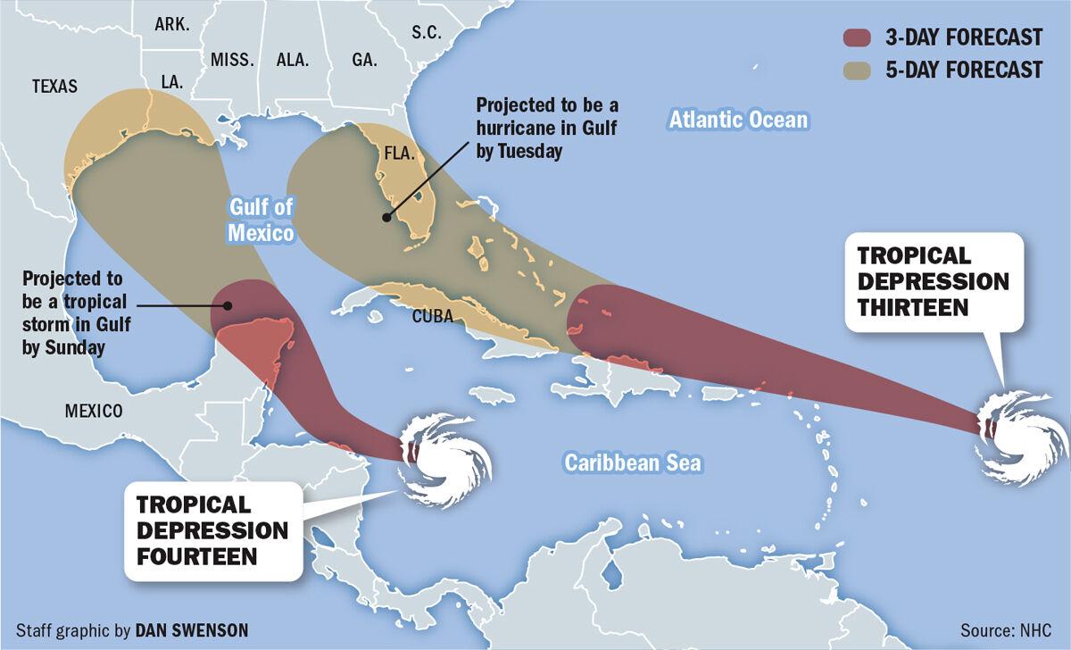
A tropical depression in the Atlantic Ocean is expected to reach the Gulf of Mexico next week as a Category 1 hurricane, the National Hurricane Center said Thursday.
It could be named Laura or Marco if it strengthens into a tropical storm. It's expected to strengthen into a hurricane on Sunday or Monday.
Forecasters also are tracking two other systems, including one in the Caribbean that's expected to develop Thursday into a tropical depression
Laura and Marco. Sounds like a morning talk show or something.
Friday, August 7, 2020
Lovely ideas, these people get
NEW: White House looking at using leftover/unspent FEMA funds to pay unemployment benefits unilaterally, 2 ppl familiar say
— Jeff Stein (@JStein_WaPo) August 7, 2020
No final decision made/things are in flux
Experts question how WH can legally pay UI benefits w/o Congress@ericawerner @karoun https://t.co/q341avJbu4
But isn't that for... yep...
Believed to be tens of billions in hurricane relief money that has not been spent. Unclear if $ for Puerto Rico would be in the mix. White House has asked federal agencies to come up with lists of $ that could potentially be moved around for the executive orders
— Jeff Stein (@JStein_WaPo) August 7, 2020
Couldn't have picked a better time too.
NOAA’s Climate Prediction Center said there could be up to 25 storms which have sustained winds of 39mph or greater. Storms which hit this threshold are named by the agency.It's going great, guys
In a normal year, there are usually two storms before August which are named.
This year, there have already been nine named storms, a record which makes 2020’s hurricane season one of the busiest on record in the US.
Subscribe to:
Posts (Atom)